The Rivers Flowing In Turkmenistan And The Artificial lake in Karakum Desert
Amu Darya, historically known as Oxus River formed by the junction of the Vakhsh and Panj rivers in the Tigrovaya Balka Nature reserve on the border between Tajikistan and Afghanistan. It starts in Pamir Mountains at altitude of about 5,000 m and flows through central Asia countries to the southern part of Aral Sea.
Total length: 2,400 km (from conjunction place 1415 km). Drainage basin: around 535,000 square km. Annual average discharge of water: 97-98 cubic km. The navigable part: 1,450 km.
The main source: the snow and glaciers in the Pamir Mountains and Tian Shan. The precipitation in the high mountains over 1,000 mm and the annual precipitation lower in the steppes less than 300 mm. It makes only 226,800 sq km drainage area active to contribute to the river waters. Average Area of Irrigated Land: 3.6 – 4 mln ha.
River tributaries: Panj, Vakhsh, Kunduz, Kafirnigan, Surkhan, Sherabad rivers.
Canals from Amu Darya: KARAKUM, KARSHI (main canal with six pumping stations), AMU-BUKHARA. Each canal has the network of water reservoirs. In the middle stream, from Kelif to Tuyamuyun, there are a dozen of canals for irrigation system. In the lower stream, the canal systems include Tashsaka, Pakhtaarna, Klychniyazbay, Urgench Oktyabr arna, Shavat, Khan yab, Kyzytken, Suenli.
Reservoir water storage: Two main - Nurek reservoir on Vakhsh river, Tuyamuyun in the lower stream, and a dozen other in-basin artificial water lakes.
In ancient times, Oxus constantly changed its course in the Karakum desert area, drifting there more sands and diverse vegetation, changing the relief and the landscapes of the desert.
At some point and until 9th century, Oxus flowed to Caspian Sea via Sarakamysh lake and its old tributary Uzboy. Around 9th century, near Kunya Urgench, the dam was built to bring more water into Chorasmia (Khwarazm), leaving without water the people of the desert and the nomads.In 13th century, Mongols destroyed the dam and the current was resumed into Uzboy and to Caspian Sea.
Between 5th-17th centuries, the significant population and farmland cultivation had been along the Uzboy river. In the end of 16th century, Amu Darya's new course and reconstruction of the dam in the Khoresm, blocked the waters into Uzboy river bed and lead to slow dry up of Sarakamysh lake. This prevented also the water supply for Turkoman tribes living in the desert what influenced their migration along the Caspian Sea, up till Kopet Dag mountains, further to the east, what makes now present day Turkmenistan.
In 1717, Russian Tsar Peter the Great sent expedition to estimate the possibility to destroy the dam and return water current into Uzboy river, that to restart waterway from Volga – Caspian Sea - Uzboy – Central Asia. Some estimates had been done but project not realized.
The river is a key source of water for Afghanistan, Tajikistan, Uzbekistan and Turkmenistan. River highly connected to the melt of glaciers and permafrost that promote summer (June – September) pick flow in the Panj and Vaksh rivers, contributing more than 40 % of seasonal river flow. This ideally coincides with the critical period of highest water demand for irrigation. Nevertheless, it seems that water formation in the Amu Darya basin is decreasing. Even more worrying is a trend related to low water years, reaching extreme minimums occurred in 2000, 2001, 2008.
Karakum (Garagum) canal: In different historic periods, there was always plan to redirect some Amu Darya waters via Sarakamysh lake to old riverbed of Uzboy river and to the reestablishing of waterway till Caspian Sea.
However, in 1954 another project started near the town Kerki. The largest irrigation project and water supply canal in the world. The construction of canal finished only in 1988, stretching the water supply for over 1,375 km and carrying 13 cubic km of water annually. Now, it is the main water supply and water source for irrigated agriculture in Turkmenistan, draining the waters from Amu Darya River.
The water reservoirs (artificial lakes) of Karakum canal:
Hauzkhan(Hanhowuz) lake – water volume 875 mln cubic m, surface area 207 square km.
Ashkhabad's eastern lake (sportivnoe) – water volume 6.3 mln cubic m, surface area 3.3 square km.
Ashkhabad's western lake (Kurtly, since 2020 Altyn Kol) – water volume 48.5 mln cubic m, surface area 11 square km.
Kopetdagskoe reservoir (lake) – water volume 550 mln cubic m, surface area 49 square km.
The snow and rain fed rivers with small or no glaciers in southern parts of Central Asia are Murghab, Tedzhen, Atrek experiencing some reduction in water flow.
Murghab river, historically known also as Margiana river. Coming from Paropamisus mountain, Afghanistan province of Marghab, enter present day Turkmenistan, passing Tagta Bazar and Yoloten districts to arrive in Mary- Merv area where it joins Karakum canal waters, 850 km long. The main tributary Kushk river flowing also from Afghanistan. Total drainage basin estimated around 46,000- 47,000 square km.
The water reservoirs, lakes along Murghab in Turkmenistan:
- Tashkenprinskoe – water volume of 9 mln cubic meters
- Saryyazinskoe – water volume of 154 mln cubic meters
- Kolkhozbentskoe – water volume of 30 mln cubic meters
- Yolotenskoe – water volume of 24 mln cubic meters
- Srednegindushskoe – water volume of 15 mln cubic meters
- Nijnegindushskoe – water volume of 16 mln cubic meters
Hari Rud river(Herirud)
River starts in the Koh-i-Baba Mountain range in the western extension of Hindu Kush, at the altitude of about 3,000 m. The rivers is 1,124 km long, but mainly 800 km flowing through Afghanistan, then along Afghan- Iranian and Iran – Turkmenistan borders, only after finally entering into Turkmenistan as Tejen river, to Karakum desert and join the waters of Karakum canal. Total river catchment area is as large as 70,000 square km. Historically, river known as Arius.
The river irrigates the fertile valley of Herat in Afghanistan, one of the water supply in Mashhad area in Iran and Tejen region in Turkmenistan. Salma Dam built on the river in Herat province for water reservoir and hydroelectricity, and another dam is Doosti Dam on the Iran – Turkmenistan border open since 2005, as water reservoir and hydroelectricity, with equal rights to the waters from both sides.
Iran- Turkmenistan Friendship Dam
- Height 78 m, Length 655 m, Width 15 m(crest), Dam volume: 4.5 mln cubic m
- Total capacity: 1,250 mln cubic m
- Active capacity: 735 mln cubic m
- Inactive capacity: 300 mln cubic m
The estimate water reservoirs, lakes along Tejen river:
- Tejenskoe 1st – water volume of 38 mln cubic meters
- Tejenskoe 2nd – water volume of 141 mln cubic meters
Due to natural reasons (droughts) the river may dry up in summertime.
Atrek is permanent fast moving mountain river, starting in Kopet Dag Mountains in Iran at the altitude of about 2,000 m. The catchment area 26.7 thousand square km, it is 635 km long and only last 135 km flowing in Turkmenistan and drains into Caspian Sea. One tributary is Chandyr river joining Sumbar river and then both flow into Atrek river. The mean annual runoff of Atrek river in Turkmenistan is 354 mln cubic meters. The river waters are very turbid; the sediments surpass all central Asia Rivers, there is around 25 kg of solid matter per 1 cubic m of water. Sumbar river is the main tributary, starts in Iran at 1,600 m altitude it runs mainly in Turkmenistan 262 km, seasonal part of the river may dry up in middle stream during summer period.
- Mamedkul – water volume of 16.4 mln cubic meters
- Kyzyl Ay – water volume of 3.6 mln cubic meters
- Delili – water volume of 11 mln cubic meters
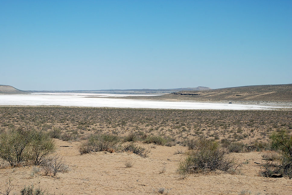
Turkmen lake in Karakum desert:
The water system of the country traditionally include the collectors for the drainage waters formed due to leaching salts in autumn – winter period, that are accumulated in soil as a result of evaporation of irrigation water in the summertime. These drainage waters are usually discharged into natural depressions in deserts. Since 1960s, the problem of drainage waters diversion became rather acute. The idea of the construction of the Trans- Caspian collector that would discharge the accumulated drainage waters into the Caspian Sea discussed but never accomplished.
The idea changed to the new project in 2000, The Golden Age Lake in the north of Karakum desert. The new Turkmen Lake located in natural depression of Karashor, with area of 3.5 thousand km and a capacity of 132 cubic km of water. The existing main collector and drainage network of the country rearranged and new collector canals discharging water in the lake constructed. The length of all canals bringing saline drainage waters are over 2,650 km. Dashoguz collector 432 km long, partly follow old Uzboy riverbed. The Great Turkmen Collector come from Lebap region, 720 km long.
Now, the Turkmen Lake in the center of Karakum desert, having currently around 580 mln cubic meters of water. The recent approval of Altyn Asyr Lake Development Concept, implement the Action Plan 2019 - 2025 for the development of the territories around the lake. Construction of the villages for the development of the livestock farming and fishing in the lake. Saplings of Saxaul trees, saltwort, Ephedra, desert Acacia and other sand tolerant species are expected to create conditions for 12 months pasture source for cattle.