Margiana in the Sasanian epoch. The detailed facts
Margiana (or Merv oasis) and Bactria kept the special place in the struggle between the Kushans and the Sasanians. In the beginning of the 3rd century AD, the states of southern Mesopotamia and the provinces of eastern Iran – Margiana, Segistan- Sistan and Kerman were virtually independent states, governed by local dynasties that only formally recognized their dependence on the Arsacids. In the first century A.D., the rulers of Margiana minted their own bronze coins, copying the types of the Arsacid silver drachms. A few of these coins bore the name of the local ruler, King Sanabares.
In the second decade of the 3rd century, when the new Sasanian dynasty of Persia marched against the Arsacids, the rulers of the eastern Iranian provinces, including the dynasty of Margiana, apparently supported Ardashir I in his struggle against the last Arsacid, Artabanus V. By 230 AD, Ardashir controlled a great part of the former Parthian territories. The rulers of Merv voluntarily recognized the suzerainty of the Sasanians while preserving for a time a certain degree of autonomy. In the list of court officials of Ardashir I forming part of the inscription on the Ka'be of Zoroaster, Ardashir's name and the names of the King of Merv and other kings of the eastern provinces headed the list. Between 240-260, the Merv ruler minted in his own name a bronze coin with the figure of a horseman and the Pahlavi inscription.
Around 260 AD, Shapur I (243-272), abolished the dynasty of Merv kings. The king of Merv is not mentioned on the list of Shapur’s court officials. Margiana became part of the administrative province that was given the name of ‘Hind, Sagistan and Turistanto the sea coast’ and was ruled by members of the Sasanian family, sons and brothers of the Sasanian king. The first ruler of this province was Narseh, the son of Shapur I. The succession of rulers of the eastern Iranian provinces can be traced up to the beginning of 4th century. Merv was an integral part of the Sasanian state. During this period, Merv minted copper coins and to a lesser extent, silver of the same types as those minted by the Sasanian state.
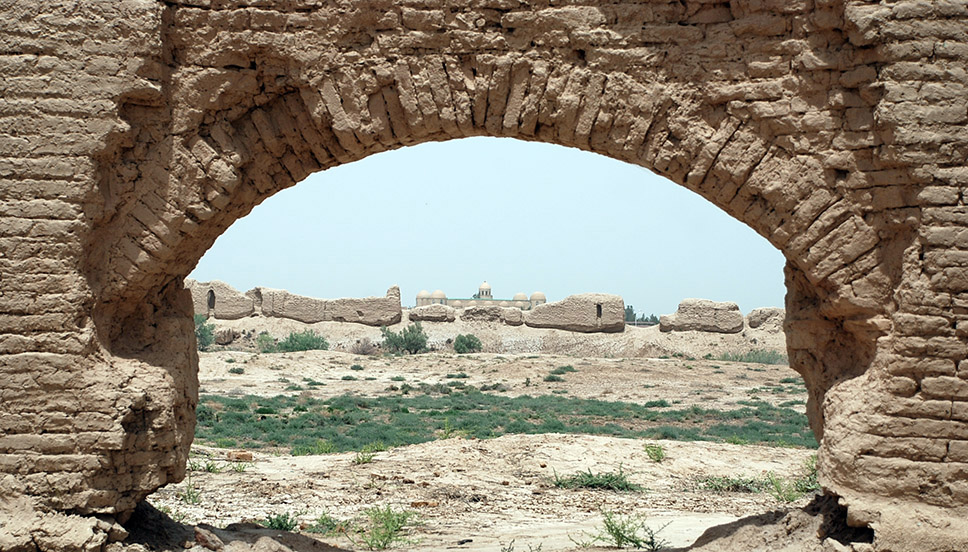
Between the 3rd and 4th centuries, the capital of Merv oasis was still the ancient Antiochia in Margiana (Gyaur Kala – present Turkmen name). The fortified site of the ancient town, covering an area of over 4 sq km, have the studies carried out on the citadel Alexandria in Margiana (Erk Kala), the fortifications, the living and workshop quarters in the northern section, the Buddhist religious building complex, a Christian monastery which was probably functioning from the 3rd century, and finally a necropolis located outside the limits, which was used from the 2nd century until the end of the Sasanian period.
The location connected Merv with Iran, Bactria and Transoxiana. It served as important information gathering point and acted as a stronghold and forward base for Sasanian campaigns beyond the eastern frontier. This aspect became clear during the wars against the Kidarite and Hephtalite Huns over most of the fifth century.
The Sasanians strengthened and reconstructed the fortresses of the Merv oasis – Childburdzh, Durnali, Chichanlik, Kirk Depe. No buildings were located within the fortresses. Settlements grew up around the walls, some remaining until Muslim times. Each fortress was used to quarter the troops who defended a particular sector of the oasis. The construction of most of these fortifications dates back to the early Sasanian period. They were erected on high adobe platforms alongside the settlements. Gebekli fortress, guarding the approach to the north-west limit of the oasis, was of unusual design. The citadel platform was enclosed by a second fortification with towers at each corner. Excavations revealed the presence of earlier fortifications of the Parthian period, though the coins found show that most of the work was erected during the reign of Shapur I.
The Sasanians did not construct major canals in Merv oasis. However, most of the canals and small aryks (small canals) inherited from Parthian period were reconstructed , cleaned several times and maintained in a good condition. Many new small canals of local importance were also added to the old irrigation system in the way that the old grid of canals supplied with water newly founded sites. The continuity of the canal system governance maintain the continuity of settlement patterns. A massive increase in the number of settlements is reported during the Sasanian period, rising from 72 in the Parthian period to 162 in the Sasanian period. All the Parthian sites continued to be occupied into at least the first half of the Sasanian period and many of those which were abandoned were succeeded by other settlements nearby. The same continuity happened after Islamic conquest as 45 % of Sasanian settlements continued to be occupied and others were re-founded nearby. Analyses suggest a cluster of settlements along the local canals flowing north, as well along the course of Murghab river.
- Based on the available archeological study, during the Sasanian period there have been in Merv oasis:
- Around 133 villages/ hamlets covering less 4 hectares area
- Seventeen small towns up to 30 ha area
- Three towns exceeding 30 ha area
- Only Merv (Erk Kala and Gyaur Kala) exceeding 100 ha area
- Other settlements have unrecorded size
This shows a high level of rural development in the Merv oasis.
- The visible mounds dated to the Sasanian period, reveal the pattern of the settlements:
- TEPE/ DEPE(circular, oval, square, rectangular and quandrangular)
- KALA(whether square, rectangular, quandrangular or irregular) and sprawling mounded settlements of irregular shape.
Both types of mounds were usually elevated on high solid pakhsa platforms, surrounded by ditches or moats.
Next category of settlement was unfortified; some located in open countryside, others were situated in close proximity to the fortified TEPE fortress. This pattern of settlement also occur in the Kopet Dag foothill zone at Abiverd and Ak Depe
- KESHK – the isolated fortified buildings, castles. Later date example in Merv buildings known as Great and Lesser Gyz Kalas
Changy Kala, Childburj and Durnali Kala (V- VII century AD) all had the unwalled extramural settlements around.
Gobekli fort is one of the best examples, it has been founded in about the second century and remained in use throughout at least the first half of the Sasanian period. Prior to excavation, it was suggested as a small early Parthian town with a ruler's house in the centre and surmised to have an economy based on local craft products being exchanged with those produced cattle rearing nomads.
Further excavations by the Moscow team headed by G. A. Koshelenko proved instead that it consists of a square fortification measuring 88 m across, with central gatehouse on the southern wall and projecting corner towers, enclosing a central building raised on its own massive platform.
The excavations revealed – the coins of the Merv horseman and Shapur I (240 AD), followed by coins of Varahran II (276 AD) and Shapur II (309 AD). The pottery, figurines and jars inked Parthian inscriptions dated by the excavators to the second half of the 4th century. Proving the continuity of Parthian language throughout the first half of the Sasanian period. These finds closely resemble those from excavations at Merv itself and independently dated to the same period. During the latest period, the earlier curtain wall, tower and central building were in filled, followed by the construction of thicker and more massive curtain walls with doors leading into rooms behind. What appears to have been a polygonal tower-like keep was constructed on the summit. Recovered from this phase were the carbonized remains of grapes and apricots reported together with grain and large number of animal bones. One report stated even late date for this last phase spanning the 5th to 7th centuries. The suggestion was that the demise of Gobekli had to do with Arab Conquest but the evidence for this is not presented. Another report mentions the presence of a number of human bone remains in the ruins of a room of the last period and suggests that the disused structure was finally reused as a conveniently elevated dakhma, similar to the evidence independently argued from Merv itself as well as the site of Shahr-I Qumis on the Damghan plain of northern Iran.
Childburj fortress – a larger fortified site, with an apparently unwalled late Sasanian extramural settlement on the western side. At first, it has been regarded as Parthian fortress and has been re-dated to the 5th century following sounding excavated in 1980. The main portion consists of an almost square site covering some 2.7 ha and surrounded by a hallow curtain with square projecting interval towers. It had a heavily defended gatehouse on the southern side. A similar construction was on the north side, presumably blocked later, perhaps in a moment of siege or military crisis, where excavators could not establish the opening. The elongated corner tower, which were probably designed to enable torsion artillery to command access to the gates.
Durnali fortress – Another walled enclosure with square projecting interval towers. Settlement was initially founded in Parthian period and continued to be occupied in Sasanian period. Its fortifications dated to the Sasanian period. Within the walls the area was divided by rectilinear streets and alleys and it was concluded that construction inside of fortress had an order. Immediately to the south, there was an extramural settlement of some 7 ha, dated by surface pottery to the 5th century.
Other type of fortified site of Sasanian period, is referred to the site at the northern side of Kone Kishan. It has Parthian component in the site but the fortifications were constructed in the 5th century. No remains of constructions found inside. Presumably it represents a campaign fort, which originally enclosed rows of tents or permanent barracks, at the northern frontier.
Therefore, the archeological evidence suggests a militarized yet prosperous pattern of settlement in the oasis with a high density of settlements of different sizes, some walled and some apparently unwalled and the largest centre being the city of Merv itself. Literary sources praise the rich agricultural resources of the Merv oasis during the Classical and Islamic periods. Although the equivalent written sources lacking for the Sasanian period. It is reasonable to extrapolate a similar situation. There is evidence for major canal off-takes from the river Murghab at this period. The purpose of these canals system was primarily to facilitate irrigation in an oasis with high temperatures and low annual precipitation doing impossible dry agriculture.
The excavated environmental evidence from Merv show the missing rural economy. Carbonised plant remains attest to the cultivation of bread wheat, emmer wheat, six-row hulled barley, broomcorn millet, cucumber, melon, almond, peach, grape and hackberry and legumes were common and provided a source of winter fodder as well as fuel. Analysis of charcoal remains also proves the cultivation of fruit trees, including apple, peach, apricot and vine.
Analysis of faunal remains indicates herding of sheep, goat for the meat and for their wool; cattle, pig, gazelle and possibly wild boar are present as food remains. Judging from the minimal number of fish bones recovered from dry sieving and flotation samples, suggest that fish played minimal part in the diet.
Equivalent environmental data for earlier periods in the oasis are still limited, although there is evidence for free-threshing wheat, hulled and naked barley, chickpeas, lentils, grass peas, cucumber, melon, grapes and plums from Bronze Age Gonur. Adding of broomcorn millet at Iron Age Tahirbai and various other cultivated cereals, fruits and other plant remains at Gobekly Depe. The fact of these crops suggest that irrigation agriculture was sustained through this period without occurrence of catastrophic salinization.
The discovery of large quantities of accidentally carbonized cotton seeds in contexts dating from the forth century onwards provides the earliest archaeobotanical evidence for cultivation of this fiber crop at Merv and contradicts the hypothesis that this was introduced as late as the ninth century. Therefore, the results imply a highly organized agricultural regime with efficient water and soil management practices, which enable the cultivation a wide range of winter, and summer crops, including the basis of an important fibre crop industry and minimized, if not averted the risk of salinization.
The more recent identification of cotton seeds from 4th and 5th century contexts at Kara Depe in modern Karakalpak, former part of ancient Khorezm, strengthen this archeological evidence for a pre-Islamic origin for cotton industries in Central Asia although it does not exclude even earlier evidence. Given the ubiquitous occurrence of spindle whorls in domestic context at all sites of these periods, it is supposed that production was at a household subsistence level or small workshops. The addition of cotton, suggests that the development of water hungry major fibre industries, alongside intensive cereal cropping and dense human populations necessitated the heavy investment in hydraulic systems in order to guarantee extra water resources.
Agricultural based societies could not be developed and existed without good water management, capable administration and effective security where the civilian and military needs are respected and the responsibilities shared.
Margiana did not possess its own ore deposits, but imported the ore material for its local metallurgical production from mines in northern Iran. Iron blooms were discovered in many settlements and an arm workshop dating to Early Sasanian times found in Merv.
Plutarch mentions Margiana's steel, which was used to make armour for Parthian soldiers. Pottery production was highly developed and potters occupied a whole quarter in Merv (Antiochia in Margiana). Kilns of the Parthian period discovered in Dzhin Depe and pottery workshops operated in many towns and settlements. Pottery of the late Parthian and Early Sasanian periods differ little in shape, although there were some changes in production techniques.Among other objects found spindle whorls and loom weights.
From ancient times, the inhabitants of Margiana were Mazdeans. In the 3rd and 4th centuries, their religious beliefs gradually transformed under influence of the orthodox Zoroastrianism of the Sasanian Empire. This reflected in a change of burial rites. The burial of bodies, which was the normal practice in the Parthian period, was supplanted by the burying of bones. Local Mazdean practices are undoubtedly responsible for the terracotta statuettes of the Margiana goddess of fertility, found in great profusion in Merv. According to al-Biruni, Christianity reached Merv 200 years after Christ birth and the first reference to a Merv bishopric dates to the year of 334. From the middle of the 3rd century a Manichaean community existed there. Erlier, possibly in the second century, Buddhism appeared and the 3rd and 4th centuries witnessed the development of a complex of Buddhist buildings in ancient town of Antiochia in Margiana.
The beginning of Sasanian period can be regarded as a time of relative economic advance, compare to late Parthian period. Economic growth fostered by the oasis having firmly part of Sasanian territory and by Merv's increasing importance as a military outpost and trade center resulting from the conquests in the east and the development of international trade.